Some have small businesses and advance enquiries might prove beneficial. One (Takeley) is a helicopter maintenance business rather than a farm strip but thought it worth including, being businesses some only work weekdays. Because they are mainly small strips often with only a few aircraft you may find everything locked up and nobody to ask for permission to visits, if so please just leave rather than walk round uninvited and make future visits harder for others.
I have put this together using personal knowledge and also reference to the following websites
http://www.laasdata.com/uploads/The-LAA ... -Guide.pdf
http://aircraftspotting.co.uk/essex-air ... guides.php
http://www.airfieldcards.com/
plus information from a book extract sent to me by Nick Challoner (Porkscratching)
to start off here is a key map of all the Essex sites with the airstrips numbered, the list under the image gives the name and location for each number
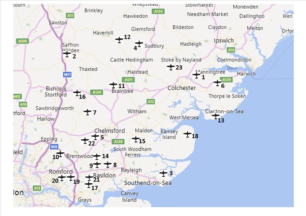 essex private airstrips numbered by Andrew Goldsmith, on Flickr
1 Ardleigh – Bounds Farm 5 miles NE of Colchester
2 Audley End 1 mile SW of Saffron Walden
3 Barling, Baldwins Farm 4 miles NE of Southend, ½ mile E of Barling village
4 Belchamp Walter 4 miles west of Sudbury
5 Fryerning – Hardings Farm 5 miles SW of Chelmsford, 1 ½ miles north of Ingatestone
6 Great Oakley 2 miles east of Wix
7 High Easter – Easterbury Fm 2 miles NE of Leaden Roding
8 Laindon, Bensons Farm Barleylands Rd SS15 4BG
9 Lt Burstead, Chase Farm (M) 2 miles SW of Billericay
10 Navestock, Jenkins Farm 2 miles SE of Stapleford Tawney airfield
11 Rayne – Rayne Hall farm spotters no longer allowed on the airfield
12 Ridgewell (Essex gliding club) ½ mile SE of Ashen and 1.5 miles east of Ridgewell village
13 St Osyth – Lodge Farm 1 mile E of St Osyth and 2 ½ miles NW of Clacton pier
14 Stock – Brocks Farm 1 mile west of Stock (aka Napps Field)
15 Stow Maries – flambards Farm 2 miles north of South Woodham Ferrers
16 Takeley – Street Farm (H) On B1256, 1 mile W of Takeley and 2 miles E of M11 J8
17 Thurrock – Kings Farm West side of A128, 1 mile S of Bulphan
18 Tillingham – Stowes Farm ½ mile west of Tillingham
19 Upminster – Damyns Hall 2 miles south of Upminster on Aveley Rd.
20 Upminster – Gerpins farm (M) 2 miles south of Upminster ½ mile W of Damyns Hall.
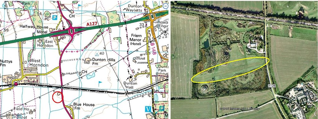
21 West Horndon, Barnards Farm 1 mile south of A127 at West Horndon
22 Willingale 2 miles NE of Chipping Ongar
23 Wormingford (E&S GC) 5 miles NW of Colchester, 1 mile S of wormingford village
I have no information on accessibility unless stated so please remember that all these locations are on private land and you should not enter without permission – do not spoil it for others. Several of the locations have public footpaths passing around (or even across) the airstrips which might help to view the airstrip or aircraft but these are mainly very small airfields often with just a handful of aircraft or microlights. The location of the main facility is circled in red on the OS extrtact (courtesy of Bing maps) and the google earth or bing aerial images have the runway(s) circled in yellow for guidance.
Ardleigh – Bounds Farm
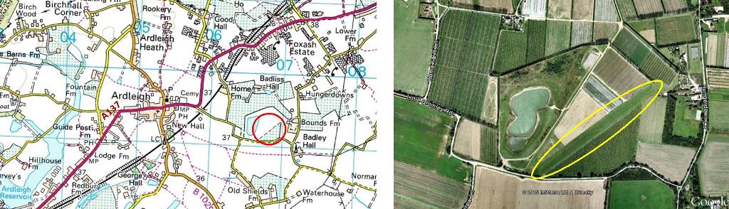 ardleigh - bounds farm by Andrew Goldsmith, on Flickr
Little Bromley road runs along the southern end of the runway so and the runway is visible from a gateway at the end, apart from that it is hidden by high hedges and the hangar is within the farm ‘yard’ and not visible from the road
No radio details found
Audley End
http://www.vintagefabrics.co.uk/service ... index.html
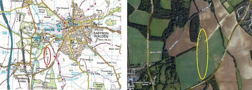 audley end by Andrew Goldsmith, on Flickr
Airfield is fairly hidden from the roads to north and south, there is a public footpath to the east of the airfield which affords some views but not easily.
Radio: 135.475
Barling – Baldwins Farm
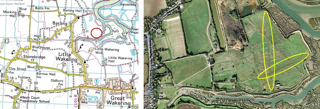 baldwins farm barling by Andrew Goldsmith, on Flickr
Airfield has 2 microlight strips and is on the farmland to the east of Barling, only public access to gain views is via the public footpaths along the adjacent sea wall
Radio: 135.475
http://airfieldcards.com/index.php/airfields-a/barling
Belchamp Walter (Waits Farm)
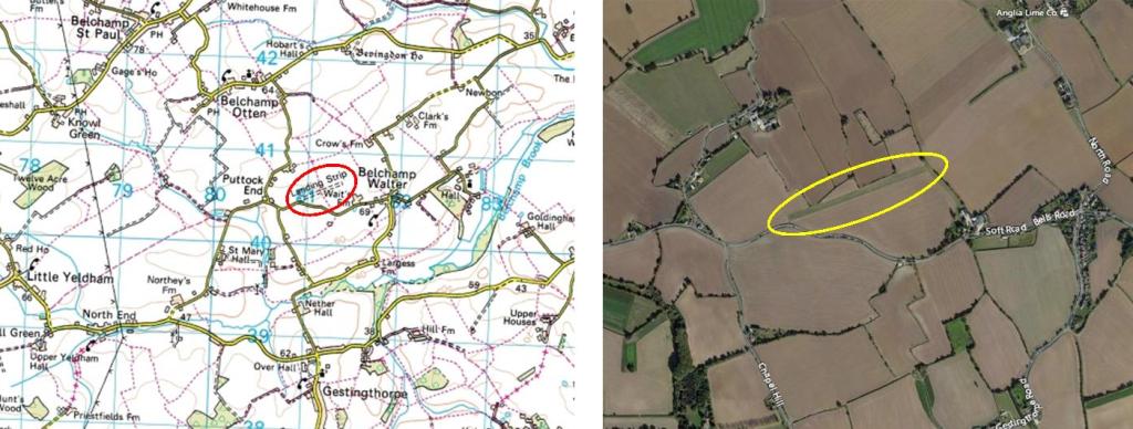 belchamp walter by Andrew Goldsmith, on Flickr
No information available, western end of runway is easily visible from road and a public footpath running north to south could be beneficial
Fryerning – Hardings Farm
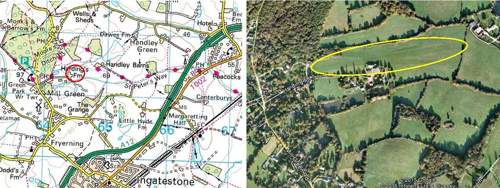 hardings farm fryerning by Andrew Goldsmith, on Flickr
No information found re airfield or radio frequency, a public footpath passes the western threshold, runs along the north side albeit partly behind a hedge and then along the eastern threshold so views of the airfield are possible via public access
Great Oakley
Website: http://www.greatoakleyairfield.co.uk
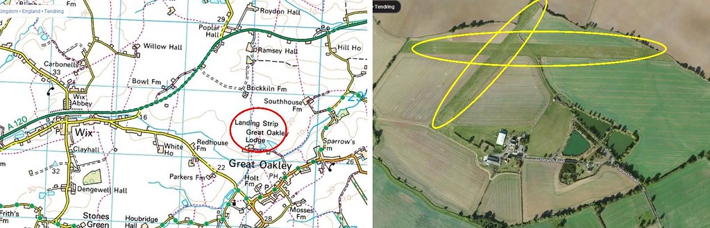 great oakley by Andrew Goldsmith, on Flickr
No information on radio frequency on website, I haven’t visited but other reports say they are friendly as long as you don’t just turn up and wander around. There is a tel no on the website but I haven’t called it
High Easter
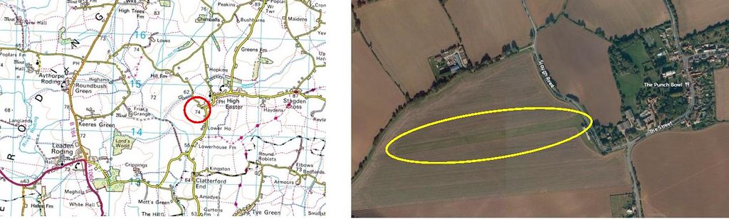 easterbury farm high easter by Andrew Goldsmith, on Flickr
No information found re airfield or radio frequency, gate onto airfield offers views of the runway but hangars are hidden behind hedge so aircraft not visible unless somebody is present to ask
Laindon
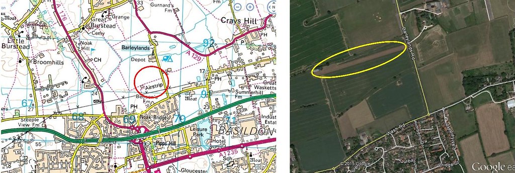 laindon, bensons farm by Andrew Goldsmith, on Flickr
I’ve been unable to find information on this site but the LAAS website quotes a visit in 2015 so it appears to be active. The location is north of the A127 and closer to Billericay than Laindon so study the map before visiting. A public footpath runs alongside the full length of the runway and hangar ( but not round or into the hangar).
Little Burstead
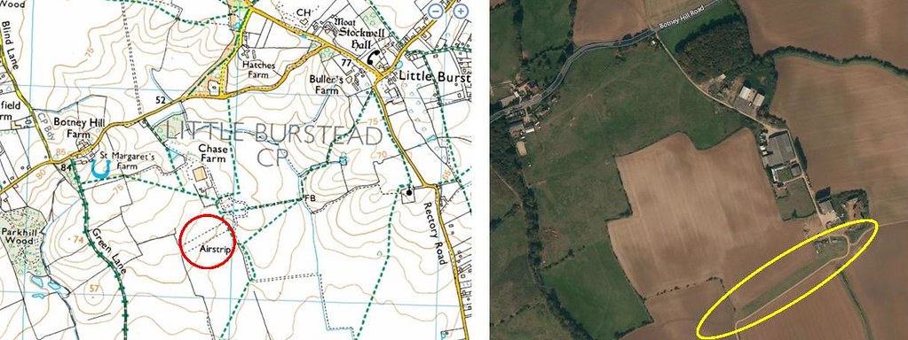 little burstead - chase farm by Andrew Goldsmith, on Flickr
This is a small microlight field well away from public roads but public footpaths run very close to it, no further information available
Navestock
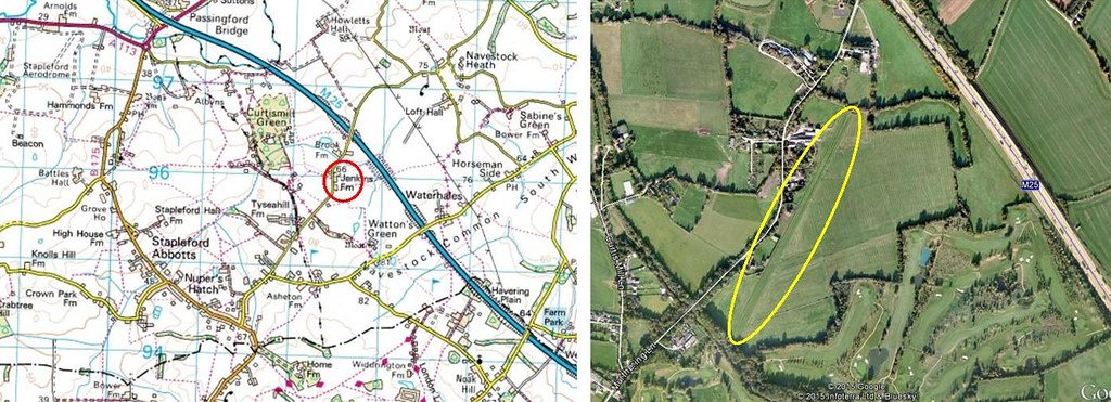 navestock, jenkins farm by Andrew Goldsmith, on Flickr
http://airfieldcards.com/index.php/menu ... enkinsfarm
the above website gives good information, including a radio frequency and warns pilots that public footpaths cross the runway
Rayne
Rayne airfield no longer allow enthusiasts to visit the airfield due to security issues so only viewing from the public footpath is now permissable
Ridgewell
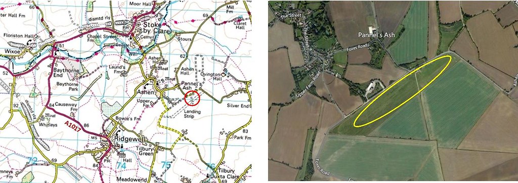 ridgewell by Andrew Goldsmith, on Flickr
Part of the former WW 2 airfield is now home to the Essex Gliding Club, the website has all the information you should need:
http://www.essexgliding.com/
St Osyth
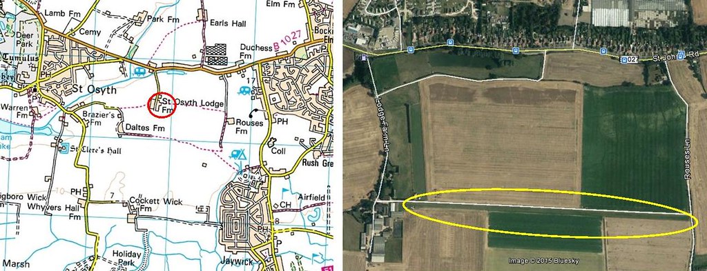 st Osyth - Lodge Farm by Andrew Goldsmith, on Flickr
Another small airstrip with a convenient public footpath alongside the runway! LAAS quotes 3 based aircraft as of January 2015, no further info found
Stock
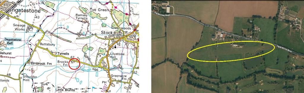 brocks farm stock by Andrew Goldsmith, on Flickr
No information available, eastern end of runway is visible from road and a public footpath runs north to south at eastern end which could be beneficial. The hangar and aircraft parking area is on a farm with business units but I have no info on access.
Stow Maries
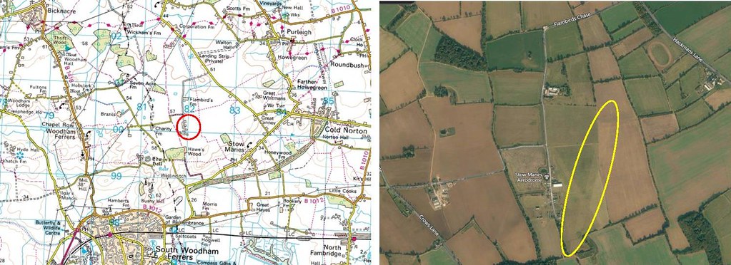 stow maries by Andrew Goldsmith, on Flickr
The former WW1 airfield is being restored and is open to the public atweekends and on occasional other days such as their annual fly ins., their website has all necessary details
http://www.stowmaries.org.uk/
Some photos (from events days):
http://www.civilianaviation.co.uk/forum ... 73&t=11459
http://www.civilianaviation.co.uk/forum ... 73&t=19350
http://www.civilianaviation.co.uk/forum ... 73&t=21986
Takeley
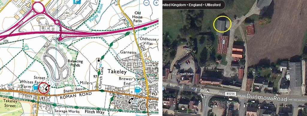 takeley - street farm by Andrew Goldsmith, on Flickr
This is a bit different to all the other sites, Street Farm is the site of the Rotorway helicopter maintenance facility which does not open at weekends. Other reports say that the facility is fairly amenable to visitors during the week
http://www.rotorway.co.uk/content/view/11/5/
Thurrock
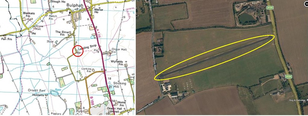 Thurrock - Kings Farm by Andrew Goldsmith, on Flickr
Kings Farm , Thurrock is unfortunately very unreceptive to visitors and prefers to remain very private (possibly due to issues with local residents) therefore access is most unlikely to be granted. It is the home of Aeroservices
and several other privately owned aircraft. Views of the parked aircraft are possible from a layby/gateway at the eastern end on the A128 or alternatively a public footpath runs along the hedge boundary on the southern side of the airfield (on the opposite side of the hedge to the airfield, this should also offer some views
http://www.aeroservices.co.uk/
Tillingham
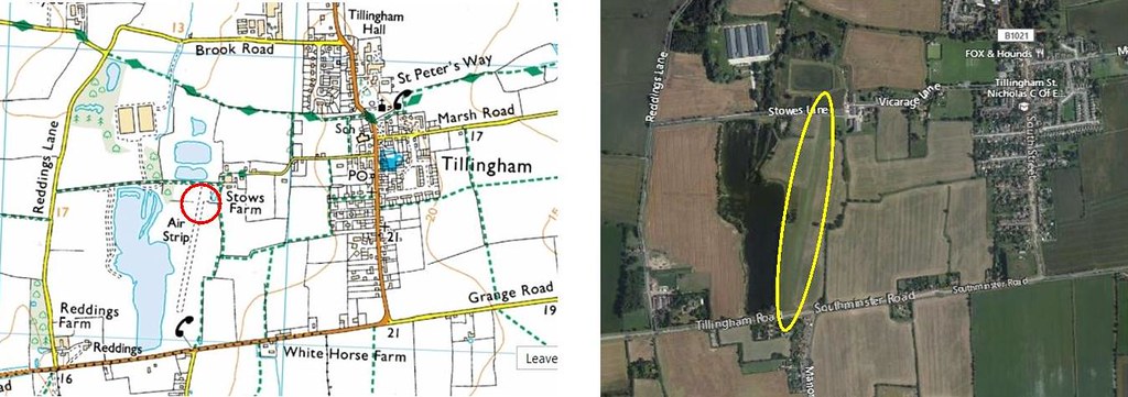 stowe farm tillingham by Andrew Goldsmith, on Flickr
No information on access found but there is a public footpath which runes north to south through the farm and then adjacent to the runway, it would probably need flying to be taking place for anything to be visible though. The runway is also visible from Tillingham Road immediately to the south.
http://www.airfieldcards.com/index.php/ ... tillingham
Upminster – Damyns Hall
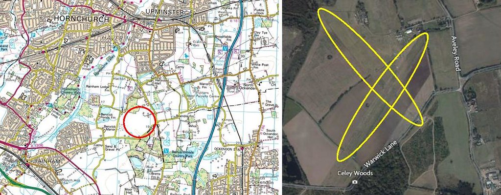 damyns hall, upminster by Andrew Goldsmith, on Flickr
Website says there is a spectators viewing area in front of the clubhouse / café, lots of info on the website including event days. LAAS gives a list of over 40 aircraft and microlights as being based in January 2015 I visited it in 2013 for an event so will search for photos later
Radio: 119.55
http://www.damynshall.co.uk/index.html
http://www.airfieldcards.com/index.php/ ... lta/damyns
Upminster – Gerpins Farm
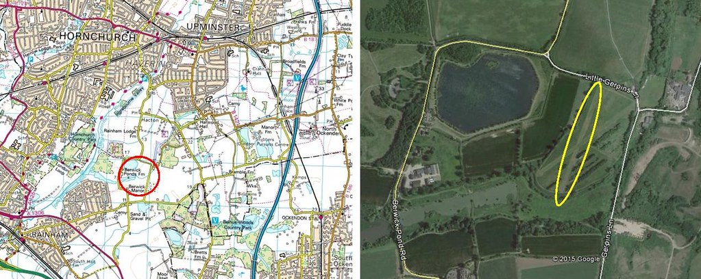 gerpins farm, upminster by Andrew Goldsmith, on Flickr
I’ve found 3 different names for this, Gerpins, Girpins and Gilpins Farm. I would like some body to confirm which is correct please. This is a small microlight field about ½ mile west of Damyns Hall. No information available on viewing etc but there is a gateway with a nearby layby at the north east corner near the junction of Gerpins Lane and lower Gerpins lane – google streetview shows good views onto the airfield
http://www.airfieldcards.com/index.php/ ... lf/girpins
West Horndon
 west horndon - barnards farm by Andrew Goldsmith, on Flickr
The airstrip is in the grounds of a garden open to the public and invites pilots to fly in PPR to visit especially for their events. As such it is possible to go into the grounds thus making the aircraft visible but an entry fee will need to be paid unless you are a paid up member of the national Gardens Scheme. This link details their opening times and events: http://www.barnardsfarm.eu/index.php/ab ... ning-times
The airstrip approach crosses the A128 on the eastern end and the hedge is lowered with some gaps through which the strip is visible but it is a fairly busy road so stopping isn’t easy. I can’t find any details of any based aircraft there although there odes appear to be a small hangar at the south east corner.
Website: http://www.barnardsfarm.eu/
Willingale
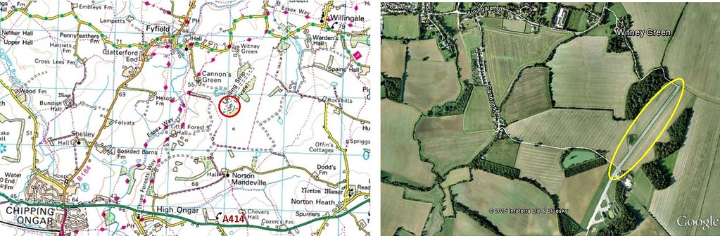 willingale by Andrew Goldsmith, on Flickr
This is part of a disused WW2 airfield and is home to about 10 microlights
Cannon Lane leads to a gated private road which in turn continues past a fishing lake to the airstrip, the aircraftspotting report says it is usually open but I personally never risk getting locked in. There are several footpaths as well as the road which lead to the airfield so finding a sensible parking spot and taking a bit of exercise might be a safer option. The above report dated 2012 says they are friendly however a LAAS report says the locals are not always welcoming, confirmation of either would be welcome please.
http://www.airfieldcards.com/index.php/ ... willingale
Wormingford
Home to the Essex and Suffolk Gliding Club http://esgc.co.uk/
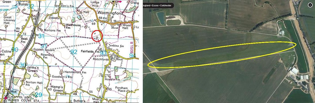 wormingford by Andrew Goldsmith, on Flickr
I have visited this airfield several times and they are very friendly. Fling is normally at weekends, Wednesdays and Fridays weather permitting otherwise you may find it all locked up. As you drive in off the public road the hangar (plus lots of glider boxes) is on your left.. There are parking spaces ahead of you. On flying days you can probably find somebody to ask for permission to go round to the launch point but this does involve going round the threshold and possibly driving alongside the live runway with towing cables descending so get instructions rather than just going around on your own. Their main concern when I visited was my safety and keeping well clear especially when a launch is in progress so take heed of what they say to you.
Here’s a link to some pics I took back in 2011: http://www.civilianaviation.co.uk/forum ... 169&t=7093
hope this is of help, any further information would be appreciated and I will add more info and photos when I find them
Andrew